
Aerial Surveys + Mobile Laser Scanning + Land Surveying &Geomatics
low cost / high accuracy kinematic LiDAR scanning specialist for surveying
Expertise
We are specialists in kinematic (moving instrument) surveys, leveraging Inertial Navigation Systems (INS) and LiDAR scanners to deliver high-accuracy geospatial data. Our expertise spans aerial surveys and mobile laser scanning, utilising drone-based, vehicle-mounted, backpack-mounted, and handheld SLAM solutions.Our unique experience and technical knowledge allows us to not only maximise the value of kinematic scanning surveys but also recognise when the technology isn’t the right tool for the job. Capturing data is only part of the equation—true value comes from understanding the technology and ensuring it is fit for purpose, applying the right methods for the best results.Conventional surveying is our foundation. We respect the core principles of the profession and integrate them with cutting-edge bulk data collection techniques, ensuring accuracy, efficiency, and meaningful/usable geospatial data.
Experience
Our principal surveyor brings 15 years of experience in kinematic surveys, starting with photogrammetry and Structure from Motion (SfM) techniques, and progressing to more advanced LiDAR scanning. Throughout his career, he has contributed directly to many large-scale government projects as well as working as a subcontractor in collaboration with other surveying partners.Recent experience includes:
Working with surveying partners to capture, process and deliver over 1,000 km (approx. 20 contracts) of engineering surveys to state specifications (<20 mm @95%) using aerial and vehicle-based LiDAR scanning, integrating conventional survey methods where necessary.
Coordinated over 2,000 survey control marks, processed to meet both state and national accuracy standards through GNSS static traverse methods.
Completed approximately 5,000 km² of topographic surveys for hydrology modelling and engineering design, utilising drone-based LiDAR scanning to achieve high accuracy (50 mm) at a large scale.
Developed advanced capture and processing methodologies for overhead line (OHL) energy distribution, in close collaboration with industry leaders. Providing heavily processed and classified point cloud data, optimised for seamless integration with market-leading OHL design software, ensuring easy import and efficient workflows.
Focus on Quality
Any experienced surveyor will tell you that even the best technology has its limitations—whether it's the accuracy constraints of GNSS or the challenge of managing large, unwieldy point cloud files for clients. We understand these challenges and take them head-on to ensure that our data products not only meet but exceed expectations.Delivering consistent, high-quality results in LiDAR scanning requires more than just advanced equipment—it demands a comprehensive approach that integrates top-tier hardware, reliable software, and a disciplined, proven workflow. Every survey is an opportunity to refine our methods and push the boundaries of accuracy and efficiency.At the core of our work is a relentless focus on both the quality and usability of our survey data. We ensure that our deliverables are not only precise but are also tailored to meet the specific needs of our clients, making the data easy to interpret, actionable, and ready for use in real-world applications.
Ideal clients
We work with a diverse range of clients, either as a principal contractor or by subcontracting to existing surveying firms to fill capability gaps. Our ideal clients include those in industries like infrastructure, engineering, environmental monitoring, and energy distribution—anyone who requires accurate, highly usable geospatial data for informed decision-making.
Training
At Motion Surveys, we utilise industry-leading inertial data (GNSS/IMU) post-processing software to deliver precise, reliable kinematic survey data. To stay at the forefront of this rapidly evolving field, our team has undertaken one-on-one specialist training, an investment we consider mission-critical to delivering exceptional results.Our surveyors hold formal, tertiary-recognised surveying qualifications, along with additional certifications in RPAS (drone operations). Motion Surveys have extensive training, workflow proofing and hands-on experience in inertial data processing and kinematic scanning.
Compliance
Motion Surveys is fully compliant with industry standards and certified by the Civil Aviation Safety Authority (certificate #6564). We also hold all necessary public liability, professional indemnity, and work cover insurances, ensuring full coverage for every project.
Location
Motion Surveys is a family-owned surveying company based in Adelaide, SA. We specialise in land surveying and kinematic LiDAR scanning services across metropolitan Adelaide and all of regional South Australia.Our experienced team works throughout the Adelaide Hills, Barossa Valley, Fleurieu Peninsula, Yorke Peninsula, Eyre Peninsula, Limestone Coast, the Riverland, and the Mid North — from Mount Gambier to Port Lincoln and beyond.While South Australia is our home base, Motion Surveys also supports clients on projects across Australia. Whether it’s fieldwork, remote data processing, or full project management, we ensure the outcomes you need for your LiDAR surveying project.
Our Work
Our mission is to provide survey-grade, cost-effective LiDAR solutions for land surveying and geomatics with the flexibility to operate in all environments. Whether in the air, on the ground, or in challenging terrain, we specialise in delivering high-accuracy geospatial data tailored to each project’s needs.
We offer GNSS, kinematic LiDAR and Structure from Motion (SfM) survey solutions suitable for:
LiDAR/imagery vectorisation to 3D CAD model
Volumetric and deformation monitoring
Pipeline and other linear asset surveys
Nadir aerial imagery and 3D textured models via SfM
Forestry and environmental assessment surveys
GNSS static control surveys

Check out some examples of our work on YouTube:

Aerial LiDAR
Drone-mounted (UAV) LiDAR is one of the most efficient and accurate methods for capturing survey data. With an optimal field of view and close-range scanning, drones make it possible to survey difficult or inaccessible areas with ease. Compared to traditional ground-based methods, they cover larger areas faster and with greater detail. Unlike manned aircraft, drones can fly lower, slower and closer to the target, improving data resolution and accuracy/precision.This advantage is especially valuable in environments with dense vegetation, where Aerial LiDAR can penetrate the canopy to generate more accurate ground models. The result is high-quality, reliable data that enhances decision-making and project outcomes.
Mobile Laser Scanning
Vehicle-based mobile laser scanning (MLS) is a powerful tool for capturing high-precision survey data, particularly for assets in close proximity to the scanner, such as road surfaces and urban powerlines. The dense, detailed point clouds generated by MLS enable precise feature extraction, allowing for the seamless delivery of vector data in CAD environments—whether it’s road markings, powerline conductors, or other critical infrastructure.Beyond its accuracy, MLS is also highly efficient. It allows for rapid data collection over large areas while avoiding much of the regulatory complexity associated with drone-based LiDAR surveys, making it a practical and cost-effective solution for many projects.
Deliverables
Accurate raw point cloud data alone has little value unless it is processed and presented in a meaningful, usable format. We specialise in data modelling, feature extraction, and file size reduction to ensure the final deliverables align with the specific needs of data users. Where appropriate, we leverage offshore processing for repeatable tasks, providing exceptional value without compromising quality.Motion Surveys delivers data in a variety of formats, including but not limited to:
Traditional CAD environment formats
GIS-compatible formats
Layered or classified point clouds
Online data visualisation and hosting
Raw or minimally processed file formats
Aerial Inspections
Drones (UAVs) offer a fast, efficient, and cost-effective way to capture high-resolution inspection imagery and thermal data. Whether used as a standalone solution or to complement 3D survey data, aerial inspections provide a level of detail that is difficult to achieve with traditional methods.By flying close to the target, drones can safely and effectively inspect critical infrastructure, such as powerlines, bridges, buildings, and other hard-to-reach assets. Thermal imaging further enhances these capabilities, enabling the detection of heat anomalies in electrical systems, roof structures, and environmental monitoring applications.With minimal disruption to operations and the ability to cover large areas quickly, drone-based inspections provide valuable insights while reducing the risks and costs associated with manual inspections.
Previous Clients
Our principal surveyor has delivered aerial LiDAR and kinematic survey solutions for a diverse range of clients. Notable organisations we have worked with include:
Contact Us
Email: [email protected]
Call us on: 0431541220
Or leave a message through the form below
QR contact card:

https://www.linkedin.com/company/motionsurveys

https://www.youtube.com/@motionsurveys

Thank You
We will get back to you ASAP
Aerial & Mobile Kinematic LiDAR Scanning
Surveying has traditionally been a labour-intensive task, requiring time and effort to capture accurate survey-grade geospatial data. Modern total stations and static laser scanners are powerful tools that have transformed the industry. However, a newer addition—kinematic scanning—is revolutionising the way data is collected. By allowing a moving instrument to capture data continuously, kinematic scanning delivers an unprecedented boost in efficiency, drastically reducing time in the field while maintaining high accuracy.
✔ Rapid capture – large sites efficiently✔ Qualified Surveyors – extensive training✔ Survey-grade accuracy – aligned to specs✔ Mobile + UAV integration – flexible platforms✔ GNSS/INS processing – reliable precision✔ Efficient data delivery – clean, usable outputs✔ Licenced & Insured – Peace of mind
At Motion Surveys, we are qualified surveyors with specialised training in kinematic data processing using GNSS and INS-driven systems. We understand, respect, and are deeply passionate about the surveying profession. This means our advice is grounded in genuine expertise, and our deliverables consistently meet the highest standards of accuracy and reliability. While others may offer similar services on the surface, we bring true survey discipline, technical accountability, and a commitment to quality that is evident in both our service and the final data products.Our solutions and survey data products have been rigorously tested and proven in the field — over the past three years, we’ve delivered more than 1,000 km of road and infrastructure surveys for Tier 1 engineering firms, using advanced LiDAR scanning methods on major government projects.
Kinematic LiDAR scanning for rapid-bulk data collection is now
Accurate | Flexible | Affordable

Over the past decade, we’ve continuously refined our services to maximise both accuracy and flexibility. This evolution allows us to deliver high-quality data capture in virtually any environmental condition—whether constrained by terrain, access, or regulatory factors. Below is a brief overview of our kinematic scanning capabilities:

Previous Clients
Our principal surveyor has delivered aerial LiDAR and kinematic survey solutions for a diverse range of clients. Notable organisations we have worked with include:

Our Work
Our mission is to provide survey-grade, cost-effective LiDAR solutions for land surveying and geomatics with the flexibility to operate in all environments. Whether in the air, on the ground, or in challenging terrain, we specialise in delivering high-accuracy geospatial data tailored to each project’s needs.We offer GNSS, kinematic LiDAR and Structure from Motion (SfM) survey solutions suitable for:
LiDAR/imagery vectorisation to 3D CAD model
Volumetric and deformation monitoring
Pipeline and other linear asset surveys
Nadir aerial imagery and 3D textured models via SfM
Forestry and environmental assessment surveys
GNSS static control surveys
FAQs & Honest Answers
What is kinematic scanning and how is it different from traditional surveying?
Kinematic scanning integrates GNSS, IMUs, and LiDAR sensors to capture geospatial data from a moving instrument. Compared to traditional stationary methods, it’s a significantly faster and more efficient way to collect high-accuracy data.Will aerial or mobile LiDAR scanning help reduce survey costs on my project?
Yes — especially on larger projects. LiDAR scanning is most cost-effective at scale. If a site would take several days to survey manually, scanning can significantly reduce time and labour. The larger the project, the greater the savings. We're always happy to advise when LiDAR is the right tool — and when it’s not.Can you combine LiDAR with imagery or traditional surveys?
Yes! We often do. Aerial LiDAR is typically supplemented with imagery to provide visual context, and we routinely integrate LiDAR with conventional survey methods where needed. For example, features like pipe inverts may still require total station or GNSS pickup. Motion Surveys has the experience to choose the right method for every situation.Will the data be fit for purpose? What formats do you deliver — point clouds, contours, CAD?
Before we start any project, we’ll confirm that the data format and accuracy will suit your project requirements. We commonly deliver point clouds, contours, and CAD or GIS-ready formats, and can accommodate specific software custom formats needs. We're also happy to discuss the best ways to visualise and use the data.What is the advantage of LiDAR over Photogrammetry (SfM)?
This is a great and common question. Photogrammetry (SfM) is a well-regarded method that we still use at Motion Surveys, but over time we've found it to be limited in real-world conditions, particularly in vegetated environments. It's more unpredictable and sensitive to factors like lighting, and it lacks the built-in quality assurance found in LiDAR (INS) workflows. While LiDAR scanning is a more expensive technology, it’s well worth the investment if you care about accurate, reliable data.What is the achievable accuracy of a kinematic scanning survey?
The power of LiDAR and GNSS/INS workflows lies in their flexibility. With the right control plan, we can tailor accuracy to suit your needs. That said, there’s a big difference in effort between achieving 100 mm and 20 mm accuracy. To meet tight engineering specs like ±20 mm @ 95%, the capture plan needs to include specialised, workflow, control and QA processes. Even with that added effort, it’s still far faster and more efficient than surveying the site "by hand".Can LiDAR work in vegetated or hard-to-access sites?
While LiDAR still relies on line of sight, a higher laser channel number and ability to record multiple laser returns (echoes) per laser allows it to penetrate vegetation and capture ground points beneath. It's not a silver bullet, but in most cases, dense vegetation or tricky terrain is far less of a barrier compared to traditional survey or photogrammetry.Do you need to shut down traffic or site operations to scan?
In most cases no. Motion Surveys has scanned and surveyed over 1000 km of regional road infrastructure without the need for expensive traffic control.Which kinematic scanning method is right for my project?
Every project has different constraints. Factors like CASA airspace restrictions, road access, topography, and GNSS reliability all play a role. In many cases, aerial LiDAR using drones is the first choice due to its wide field of view and efficiency, but other scanning methods may be a better fit, or used to supplement coverage. We’ll recommend the best approach based on your specific project needs.Why consider Motion Surveys?
We’re a small, family-owned business that genuinely wants to provide a great service. We offer honest advice and are not driven by sales targets — we’re here for the challenge of working on interesting, meaningful projects. As qualified surveyors with over 10 years of experience (including advanced training in INS processing), we’ve worked across everything from small local jobs to major infrastructure projects.
Asset Inspection
Our drone inspections enhance our core service LiDAR scanning surveys by adding visually rich data such as high-resolution imagery, video, and thermal sensing. These tools provide a cost-effective way to gain a detailed aerial perspective and valuable insights into your project.Drones allow us to safely and efficiently capture close-range imagery for desktop asset analysis or wide-area coverage suitable for photogrammetry (SfM), 3D modelling, or creating orthorectified maps. This flexibility makes drone inspections a powerful addition to our primary LiDAR surveying services.
✔ Close Range Imagery – mm resolution✔ Reality Models – 3D asset models from SfM✔ AI Asset Defect – Data suitable for AI defect detection✔ Thermal Imaging – Identify asset hotspots✔ Aerial Video – Valuable aerial perspectives
Asset Digitisation
Our process combines precise data capture with advanced processing to produce detailed 3D models and digital twins. These models enable precise measurement, condition monitoring, and long-term asset management.With asset digitisation, clients gain valuable insights that support smarter decision-making and improve operational efficiency across the asset lifecycle.

Applications and Industries
Roof and Building Inspections
Road and Rail
Solar Farm Inspections
Oils & Gas
Powerline and Tower Inspections
Renewables Infrastructure
Telco & Radio Tower Inspections
Environmental
Energy distribution
Water Utilities
Bridge and Inspections
Powerline Surveys
Motion Surveys specialise in LiDAR surveys for above-ground energy distribution infrastructure. We have extensive experience delivering mobile LiDAR scanning for energy stakeholders and have developed flexible capture workflows to suit all environments. Our processing workflows produce lightweight, easy-to-use models that integrate seamlessly with industry-standard software such as PLS-CADD and Neara.The nature of energy distribution networks, long, linear assets, creates a challenge: how do you efficiently capture accurate survey information across vast corridors? Traditional survey methods are often slow, inefficient, and limited in the detail they provide. Manned aircraft surveys can cover ground quickly, but the resulting data is typically lower in accuracy and density, restricting its usefulness.Motion Surveys provides a better approach through close-range kinematic LiDAR scanning. Our workflows deliver survey-grade accuracy with ground-level quality assurance, ensuring data reliability from capture to delivery. Scanning options are adaptable for both rural and urban environments, and while our raw datasets are dense and highly accurate, our final outputs are carefully optimised into lightweight, easy-to-use models compatible with industry software.
The data in the video below was captured using our mobile backpack system primarily design for capture in urban areas. The YouTube link above takes you to a short video.
Top Benefits of Motion Surveys’ Kinematic LiDAR Methodology for Energy Distribution:
Survey Grade Accuracy - precise data capture suitable for engineering design
High-density raw datasets –Rich detail enabling advanced analysis and multiple downstream uses
Efficiency over long corridors - rapid mobile capture optimised for linear assets
Adaptable workflows - tailored approaches to meet project- or site-specific requirements
On-the-ground quality assurance - direct control of capture and referencing ensures dependable results
Lightweight deliverables - optimised survey models that are easy to use and integrate seamlessly
Reduced cost and risk - a proven method that improves safety while lowering operational costs
Drone-based LiDAR has become one of the most effective ways to survey high-voltage transmission lines. By flying along the corridor, UAV LiDAR systems capture millions of precise measurements that map every pole, conductor, and surrounding feature in detail. This data allows asset owners and engineers to better understand vegetation encroachments, ground clearances, and potential risks, all while reducing the need for time-consuming ground access or working in hazardous environments.
Compared to traditional survey methods, drone LiDAR is faster, safer, and more cost-effective. Large sections of line can be captured in a single day, with minimal disruption to ongoing operations. The resulting datasets can be processed into 3D models, digital terrain surfaces, and clearance reports tailored to regulatory requirements. This combination of efficiency and accuracy makes UAV LiDAR a powerful tool for utilities managing critical transmission infrastructure.
Topographic Site Surveys
For medium to large development sites, drone-mounted LiDAR systems or other kinematic scanning solutions provide the backbone of the survey with unmatched efficiency.A raw LiDAR point cloud can generate the following elements of a site topographic survey:
Ground Surface (DTM) and contours
Electricity OHL conductors
Buildings
Vegetation footprint
Significant Trees
Road bitumen surface
Access Tracks
Line Marking
Fence lines and gates
Tops & toes
Misc. above ground features
In short, drone LiDAR is a game-changer for the land surveying industry, especially for complex topographic surveys. This technology delivers unmatched speed and accuracy in data acquisition, providing a complete digital twin of your site in a fraction of the time. This advanced approach to 3D mapping results in a streamlined workflow, reduced project costs, and a significant return on investment (ROI), making it an essential surveying solution for any modern development project.
Mining & Quarries
In the demanding environments of mining and quarrying, operational success hinges on precision and safety. Traditional surveying methods are often slow, hazardous, and disruptive, leading to costly downtime. Our advanced drone surveying solutions revolutionise this process, utilising state-of-the-art LiDAR and photogrammetry to provide a comprehensive, data-rich overview of your site. We empower you to manage assets, monitor progress, and plan operations with a level of detail and efficiency that was previously unattainable.
Rapid Data Collection
Survey-Grade Accuracy
Cost Effective
Fast turn around
On the ground QA survey
Safe & Efficient
Our methodology is centred on efficient and safe UAV data acquisition. The use of drone survey platforms allows for rapid site mapping with minimal ground disturbance, leading to a fast turnaround on deliverables like digital terrain models (DTM). The LiDAR point cloud data collected is of survey-grade accuracy, providing a reliable dataset for land surveying that is both cost-effective to acquire and suitable for detailed technical planning and analysis.
Catchment Hydrology Surveys
Drone LiDAR technology has revolutionised the way catchment hydrology surveys are carried out by providing a rapid and accurate method for collecting detailed topographic data. A drone equipped with a LiDAR sensor captures millions of laser returns across the landscape, while onboard GPS and IMU systems record the exact position and orientation of each pulse. The resulting point cloud is processed to classify ground and non-ground features, allowing highly accurate Digital Elevation Models (DEMs) and Digital Terrain Models (DTMs) to be generated. These models are then used for hydrological analysis, including catchment delineation, flow path mapping, hydraulic modelling, and environmental monitoring. This workflow provides critical data for flood studies, erosion assessments, and the design of water-related infrastructure, making drone LiDAR an efficient and powerful tool for understanding and managing catchments.
Rapid Data Collection
High Accuracy
Cost Effective
Safe & Efficient
Motion Surveys has delivered more than 5,000 km² of hydrological catchment survey data since 2022. Through efficient workflows, we provide lightweight, ready-to-use deliverables that integrate seamlessly with hydrology modelling software. Our data deliverables is truly plug-and-play.
Road & Corridor Surveys
Engineering surveys for road design require accurate and precise road surface and terrain modelling. Traditionally, this has been a tedious task, collecting cross sections by hand with a total station or occasionally with fixed tripod scanning.Enter Kinematic scanning.This technology is now available, and Motion Surveys is at the forefront of developing survey-grade solutions. We combine mobile laser scanning (MLS) with drone (UAV) LiDAR to meet both state and national government survey specifications. Our methodology has been proven and repeated across more than 20 major projects.
OVER 1000KMs DELIVERED SINCE 2022
With over 1000KMs or engineering road survey processed and delivered Motion Surveys have overcome the following challenges along the way.
| Element | Problem | Solution |
|---|---|---|
| Accuracy | LiDAR scanning not typically accurate enough | Developed over years Motion Surveys have workflows to meet government survey specifications and client needs |
| Data Size | Point cloud surveys are two big to use for design | Our survey data deliverables are produced from high resolution raw data and then reduced to optimal sizes without compromising accuracy |
| Data Type | Point cloud data is not suitable for design | We provide a survey model that resembles a standard survey model and drawing presented in CAD |
| Non Visible Features | Not all elements of a typical survey are visible in a point cloud | Absolutely correct. Some features are required to be picked up by hand such as culverts/invert levels and underground services |
| Turnaround | The time for delivery of a road survey is too long | Kinematic scanning is super fast! Our methodology scales well, the longer the road the relative timeline of the survey improves |
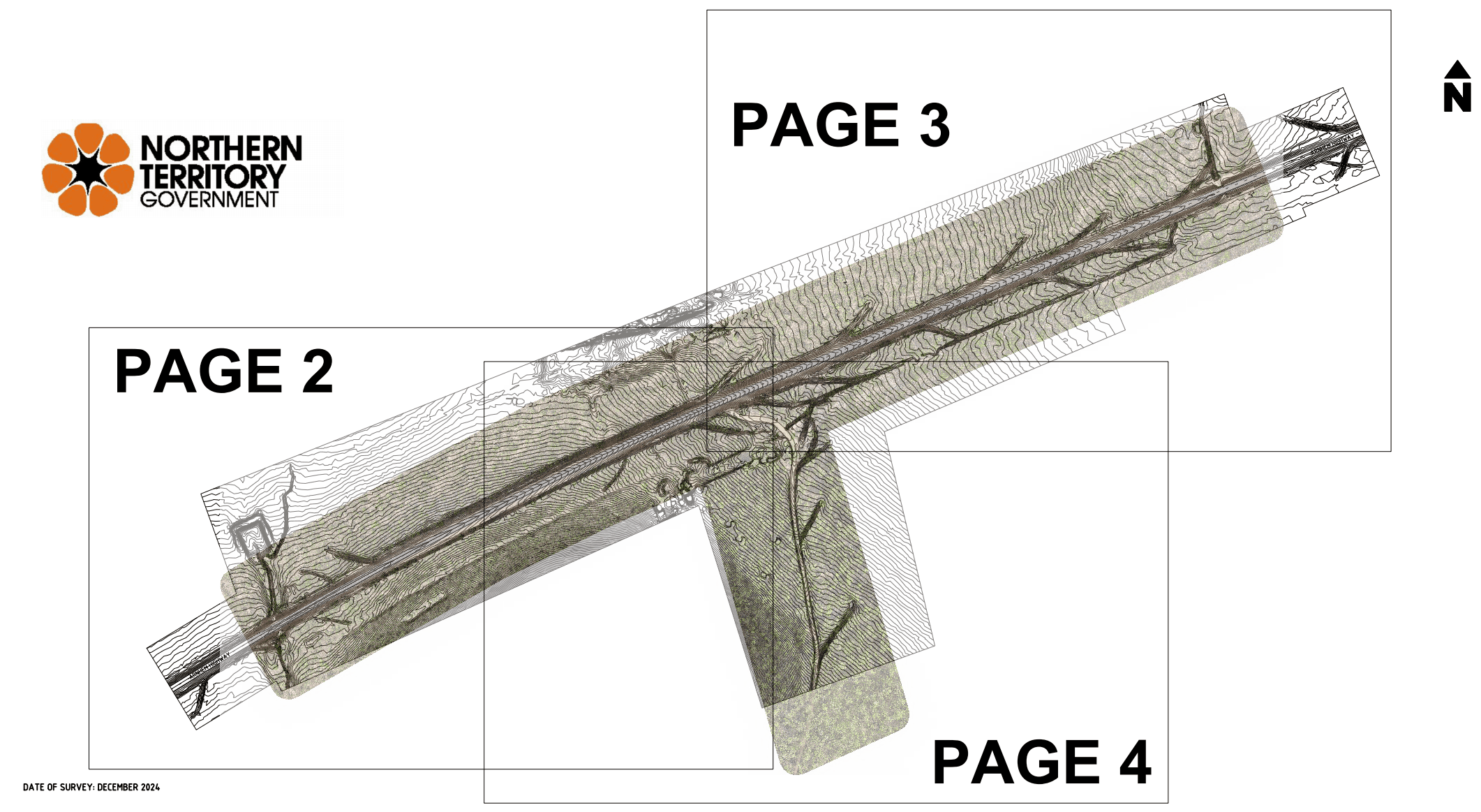
Screengrabs
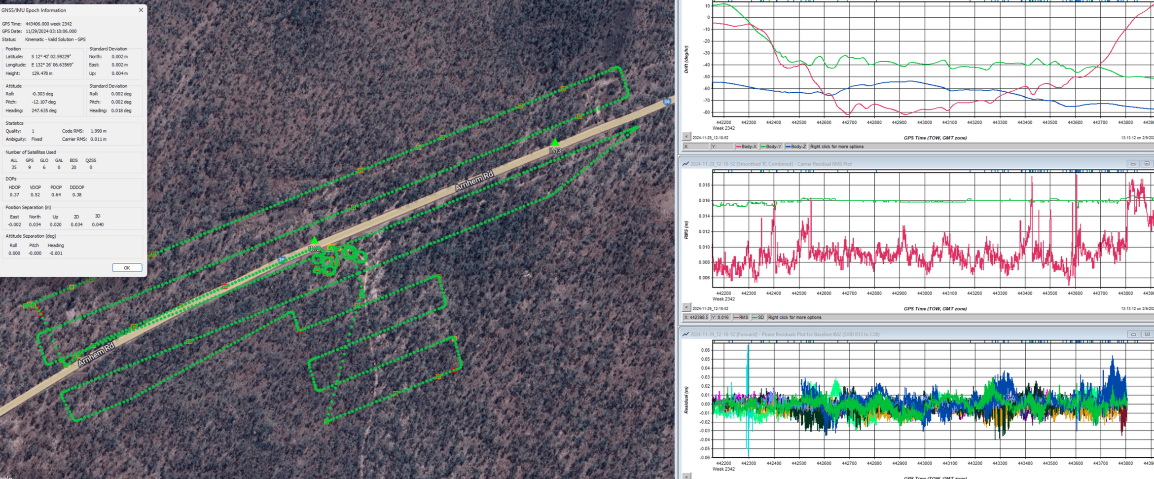
At Motion Surveys we love a good screenshot! Below is a selection of visuals and descriptions from recent Kinematic LiDAR scanning surveys we've completed. We put a lot of love into every survey and we hope these data shots help reflect that.
Residential Development Site Detail Survey
This aerial LiDAR survey supported the civil design and planning of a large, multi-stage residential subdivision on a greenfield site with dense vegetation and medium to long grass cover. Due to the site conditions, a carefully planned and precise flight strategy was required to ensure high-quality raw data capture.
The aerial data capture was completed in a single day, with ground-based QA surveys conducted shortly after. High-resolution imagery and raw LiDAR point clouds were processed and vectorised into a detailed, layered 3D survey model, delivering accurate topographic data to support design and planning workflows. Extracted survey accurate information included:
DTM and contours
Electricity OHL conductors
Buildings
Vegetation footprint
Road bitumen surface
Line Marking
Fence lines and gates
Creek tops & toes
Accuracy quantification & QA reporting
Utilising kinematic LiDAR scanning as the backbone of this large-scale detail survey delivered significant time savings for the primary survey contractor. The return on investment from this high-efficiency data capture method was substantial without compromising accuracy.
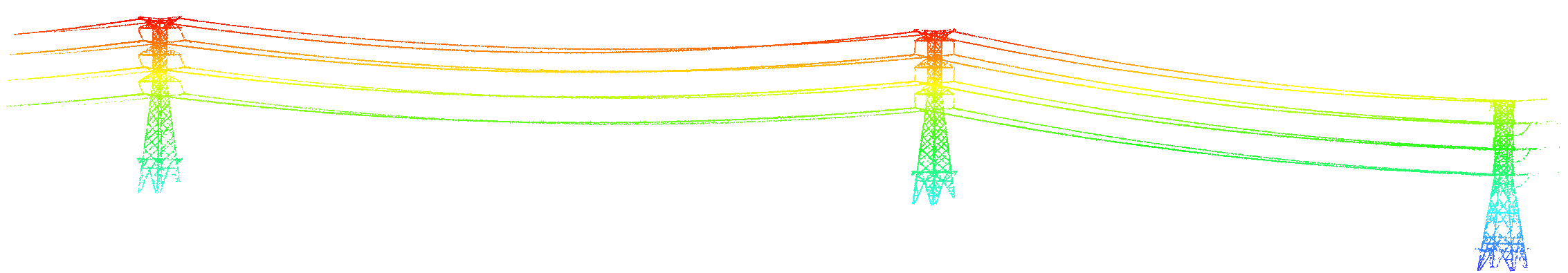
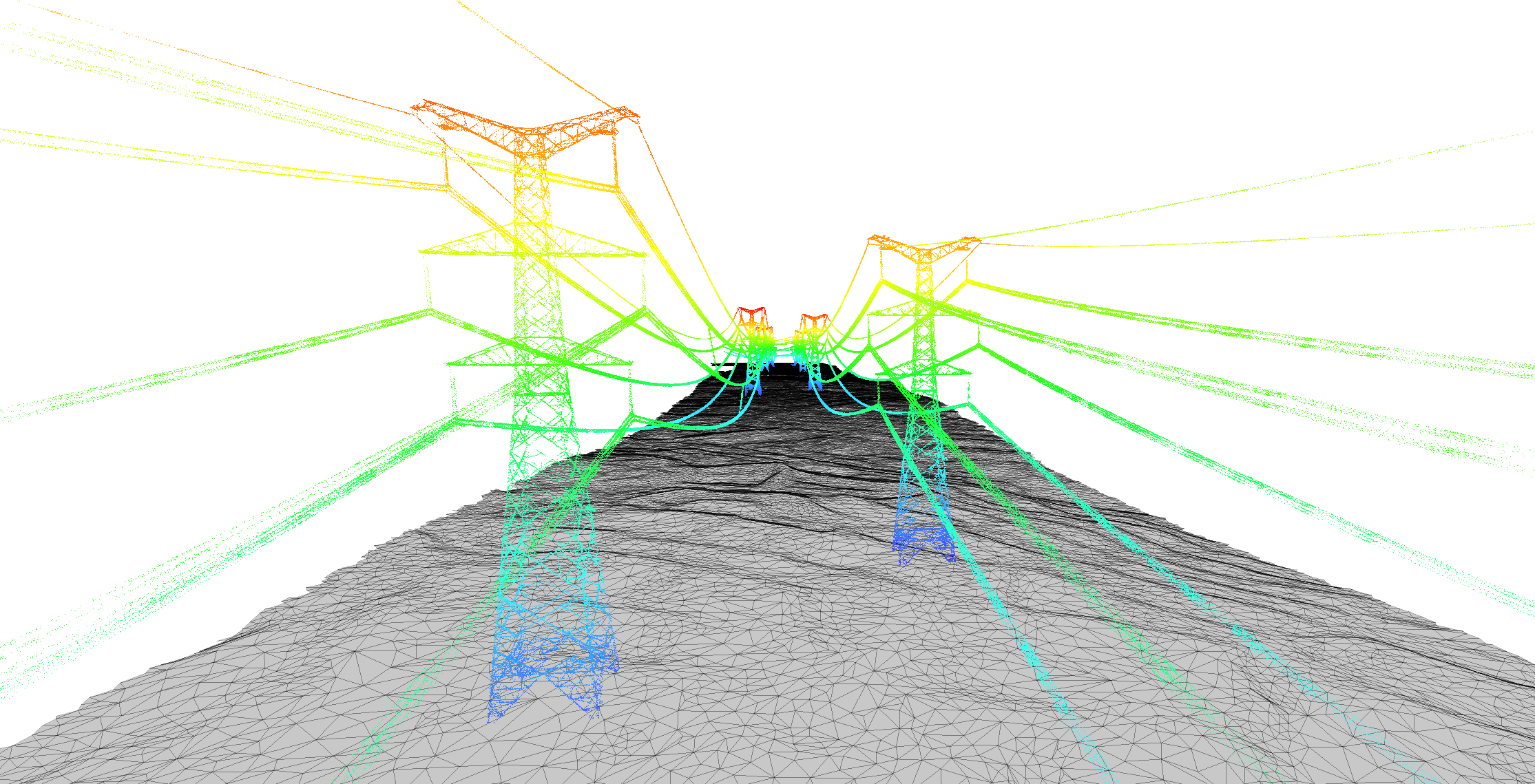
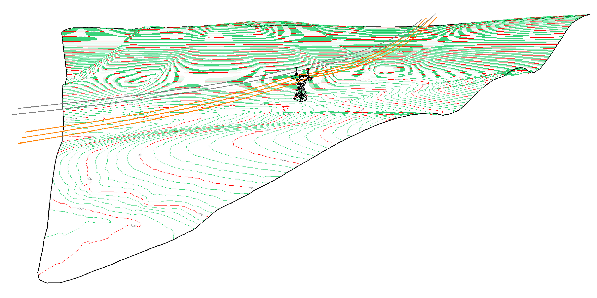
HV Transmission Lines - LiDAR Scan
Aerial and mobile LiDAR capture high-voltage transmission lines with precision—ideal for modelling, asset inspection, and vegetation clearance analysis. Fast, accurate, and non-intrusive.

Below is a mix of high-voltage (HV) and low-voltage (LV) overhead lines (OHL) captured as part of a large-scale topographic survey by Motion Surveys.The resulting digital twin was fully vectorised, including conductor alignments, pole and asset locations, surrounding topography, vegetation footprint, and more; providing a comprehensive dataset for design, planning, and asset management.
Quarry Aerial LiDAR Survey
This aerial LiDAR scan of a quarry site was processed to extract precise ground data, generating a high-resolution Digital Terrain Model (DTM) and contour map. The screenshot below showcases the true effectiveness of drone-based (UAV/RPAS) aerial LiDAR for topographic mapping, capturing complex terrain with exceptional accuracy.
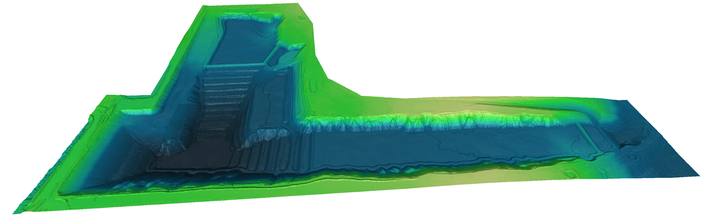
High Accuracy Road Survey
Here’s an example of LiDAR data processed into a road engineering survey requiring high accuracy and high attention to detail.The raw scan data has been reduced and drafted to the CAD environment and is required to meet state survey standards. The survey model contains all required features for design as would be provided conventionally.
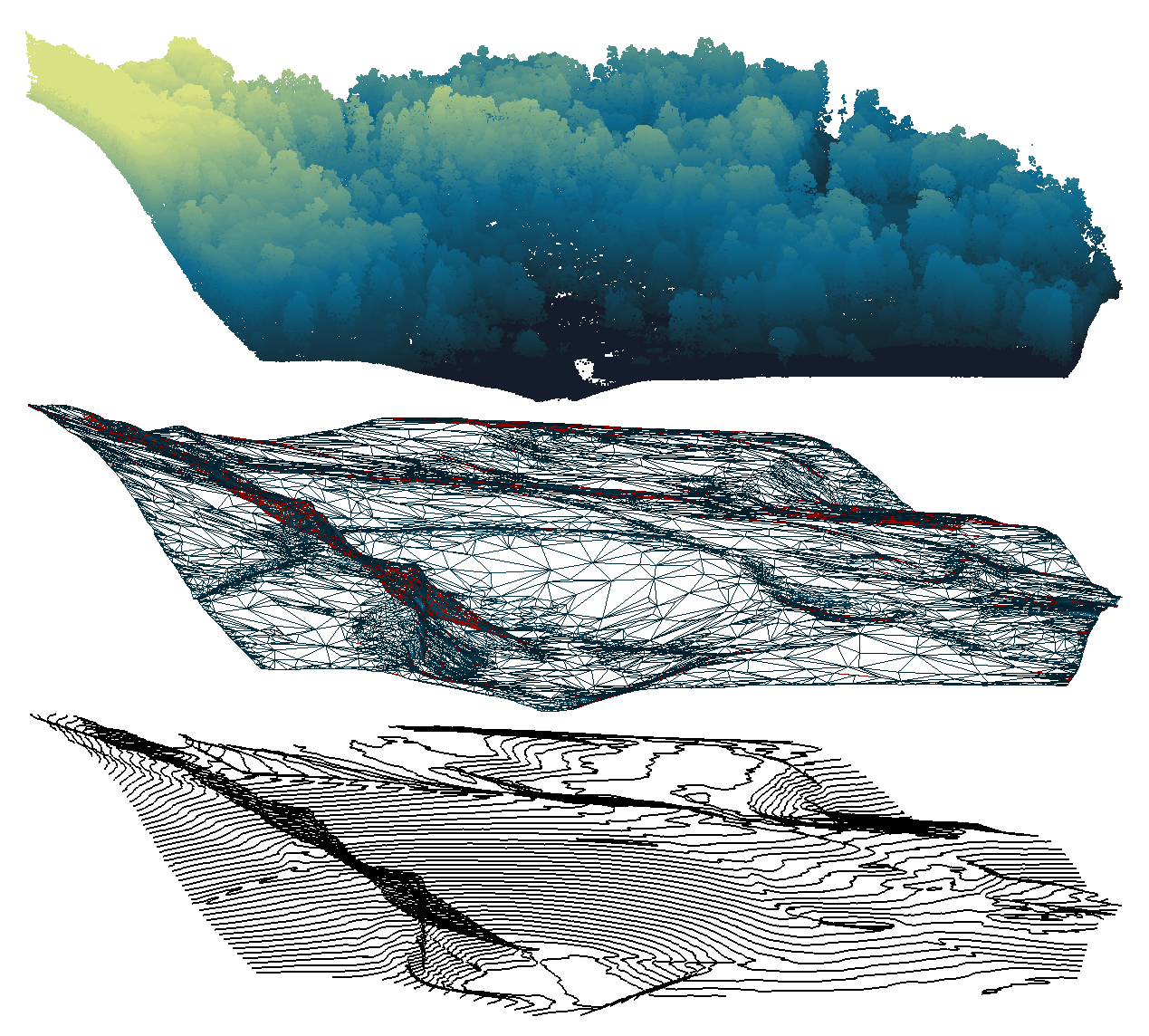
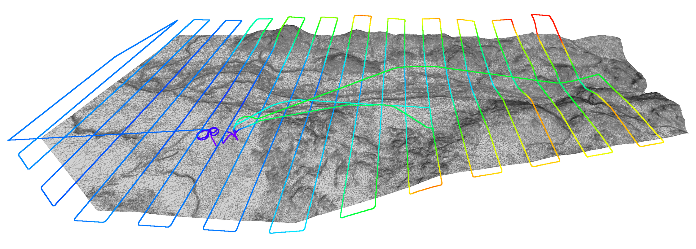
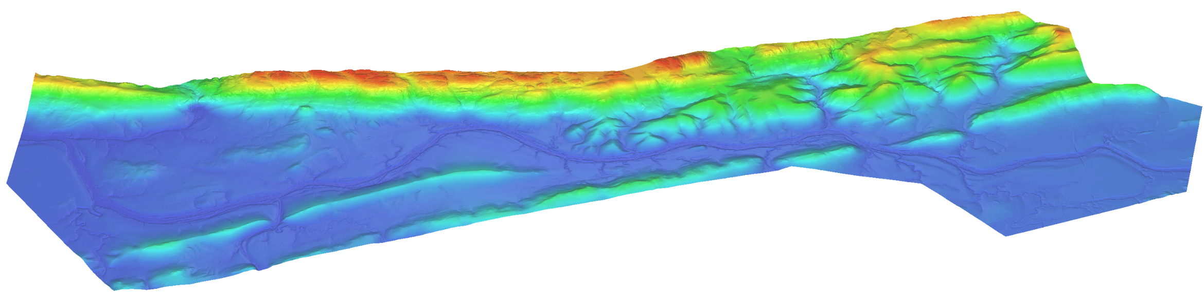
Topographic 3D DTM Model
This topographic survey was conducted using a drone-mounted LiDAR scanner to support hydrology modelling. The dataset captures detailed terrain features, enabling accurate watershed analysis. The displayed flight trajectory illustrates the survey coverage.
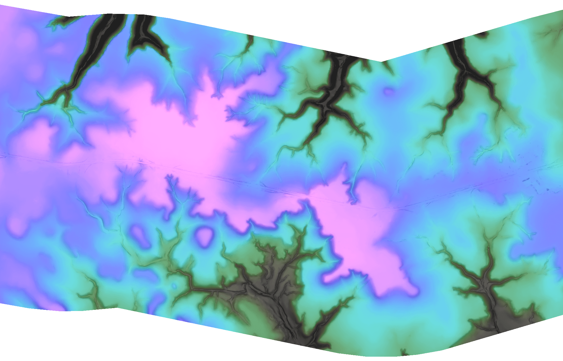
Hydrology Catchment Survey
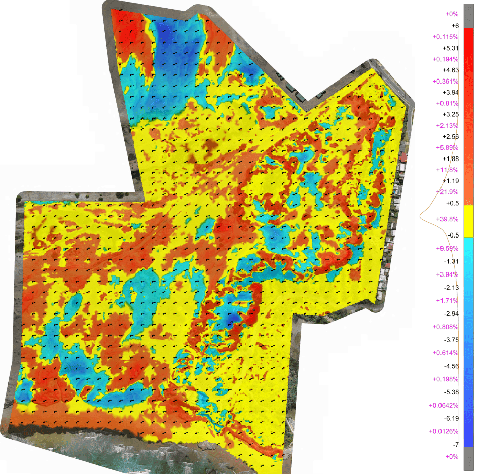
High-resolution aerial LiDAR captured by drone offers a fast, efficient way to generate detailed hydrographic models. These models help avoid costly overdesign by revealing the true complexity of terrain and water runoff. The example below shows a catchment survey where intricate drainage patterns were uncovered—enabling a more precise and cost-effective approach to road engineering.
The video below outlines a 1000Ha survey was undertaken with a drone mounted LiDAR scanner to capture an extensive area quickly in high detail. The RAW data is then modelled to a ground surface model (DTM) and checked against independent QA survey pre delivery.
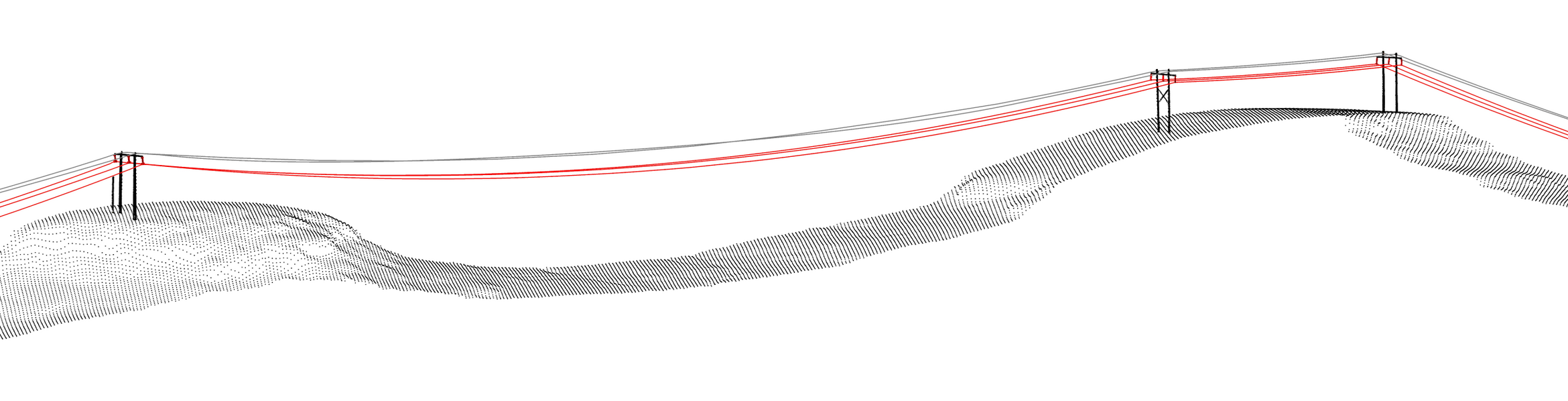
3D Survey of Transmission Lines in Steep Terrain
Challenging terrain can be efficiently captured using aerial LiDAR, enabling accurate ground modelling and extraction of key site features. This steep section of high-voltage (HV) powerlines was mapped in a single flight, overcoming difficult access and elevation changes.
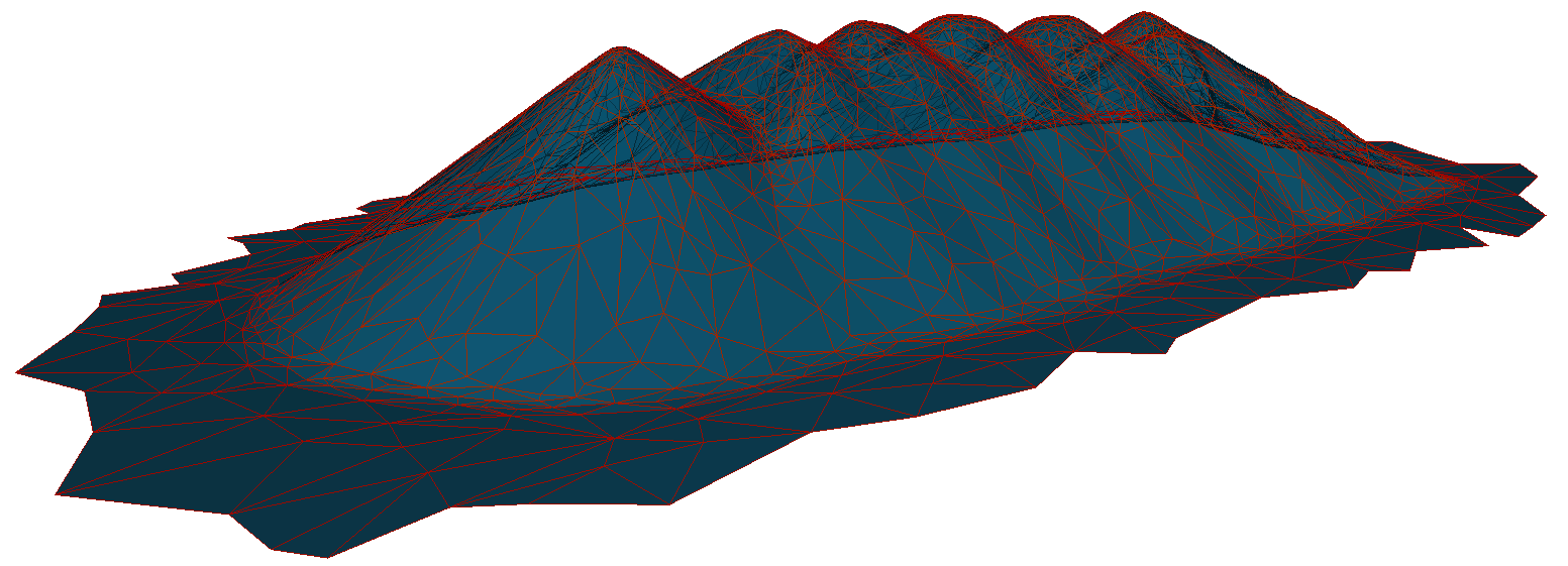
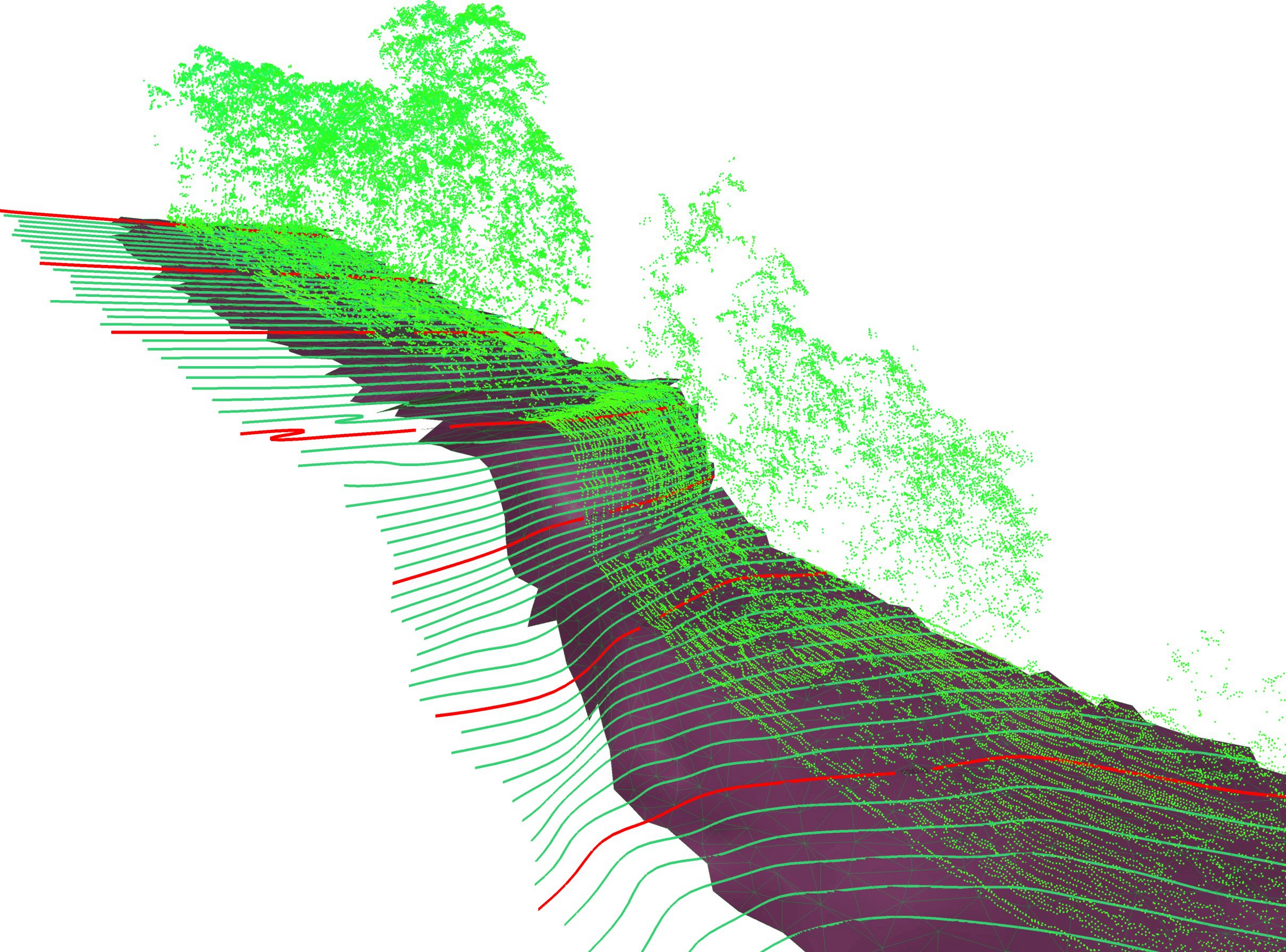
Large LiDAR Catchment Survey
High-resolution LiDAR data enhances modeling of steep, vegetated terrain. Below is a large topographic survey capturing extreme elevation changes.
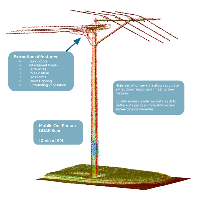
R&D Backpack Mount - Urban OHL Survey
Motion Surveys has developed and proven a backpack-based LiDAR system and workflow that expands the possibilities of ground-based surveying. Originally designed for powerline projects in urban areas where CASA restrictions limit drone use, the system provides a flexible and efficient alternative.Our backpack solution captures high-density data of overhead line (OHL) infrastructure and surrounding environments, generating a detailed RAW point cloud digital twin. From this, we deliver classified outputs or lightweight, design-ready models compatible with PLS-CADD and other engineering platforms.
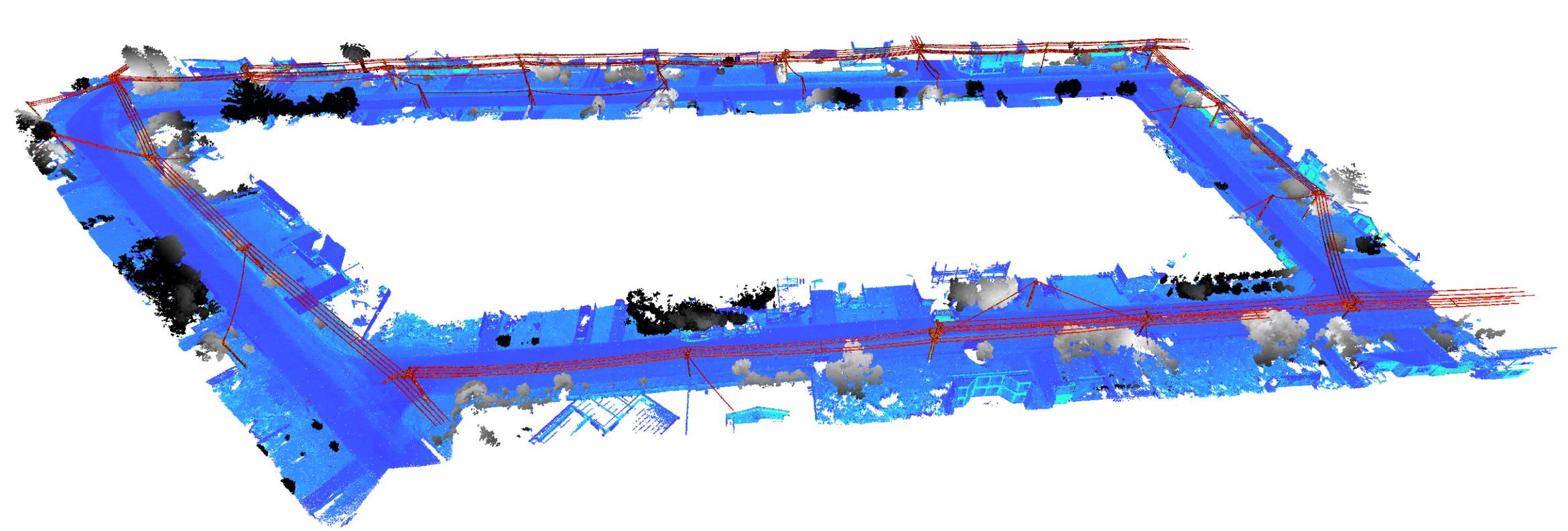
Mobile scanning at ground level often introduces challenging GNSS conditions, making it difficult to achieve survey-grade accuracy in LiDAR point cloud data. Motion Surveys has developed proven workflows and processing techniques to overcome these limitations and consistently deliver reliable, survey-grade outputs.
We made a video to help show some R&D work:
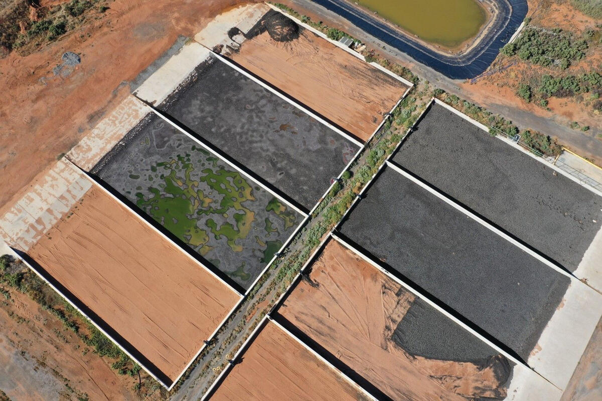
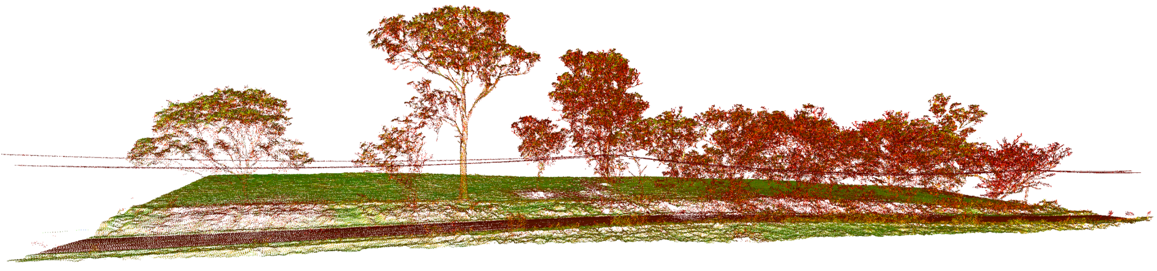
Deformation Monitoring of Sand Dunes
Aerial LiDAR surveys are highly effective for environmental monitoring, providing precise data to track changes over time. Below is an example of a project monitoring sand dune shifts, where repeat surveys capture subtle variations in elevation and movement. This data is invaluable for coastal management, erosion studies, and environmental impact assessments.
Mining Site LiDAR Survey for Volumes
Using drone LiDAR scanning, mining and landfill sites can be safely captured and modeled without the need for human access. This method eliminates safety risks associated with hazardous or unstable terrain while delivering high-resolution, georeferenced survey data.
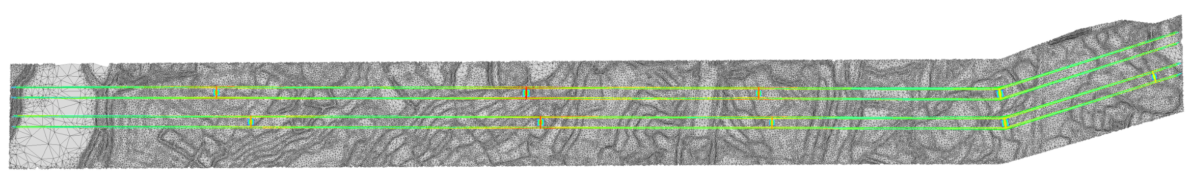
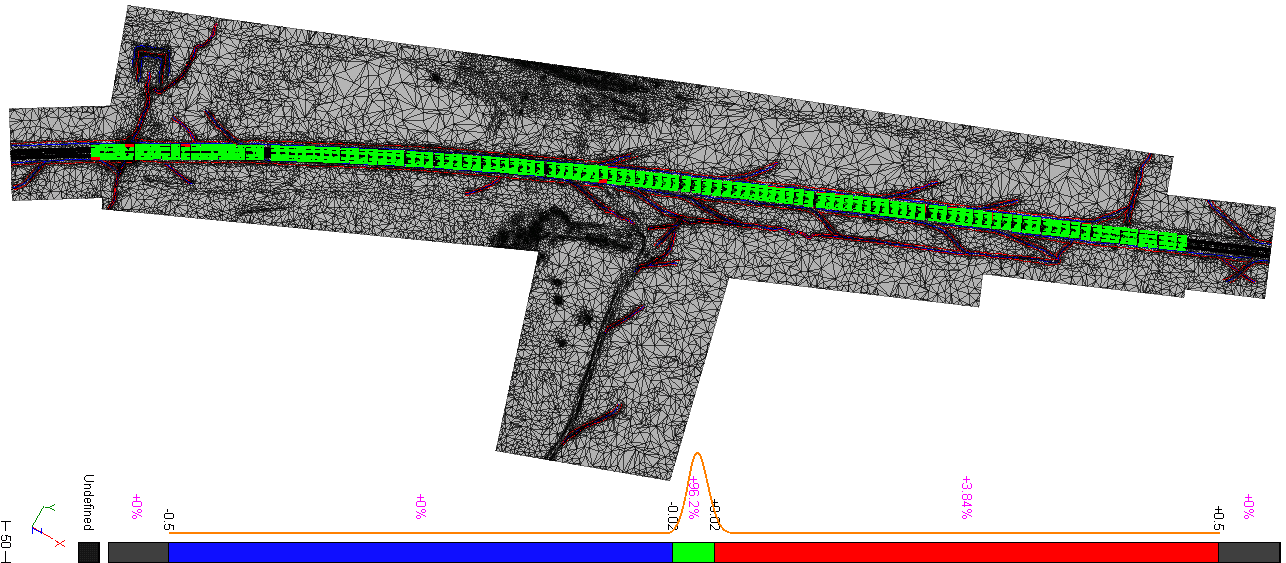
Road Surveys - LiDAR vectorised 3D CAD Model
Converting raw LiDAR data into traditional CAD deliverables is often an overlooked step in the industry. However, precise feature extraction and data presentation ensures seamless integration into engineering workflows.
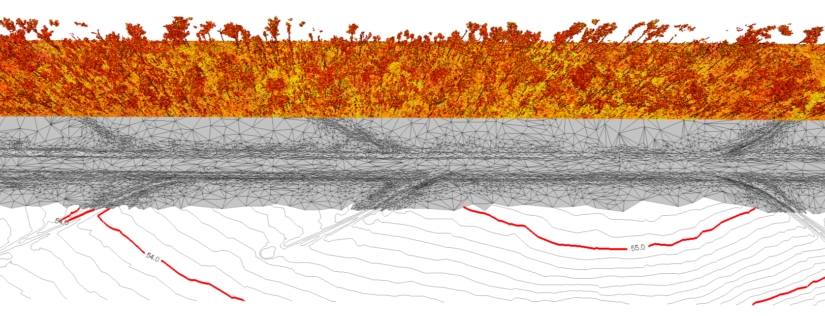
These images are an example of a small road engineering survey, processed and drafted to meet state survey specifications. Critical elements such as road edges, centrelines, drainage, and terrain contours are accurately represented, providing engineers with ready-to-use data for design and analysis.

This survey was held to an engineering specification of 20 mm accuracy at 95% confidence. An independent total station check confirmed the results were well within tolerance, demonstrating the reliability of our kinematic capture and processing workflow. The results are visualised below.
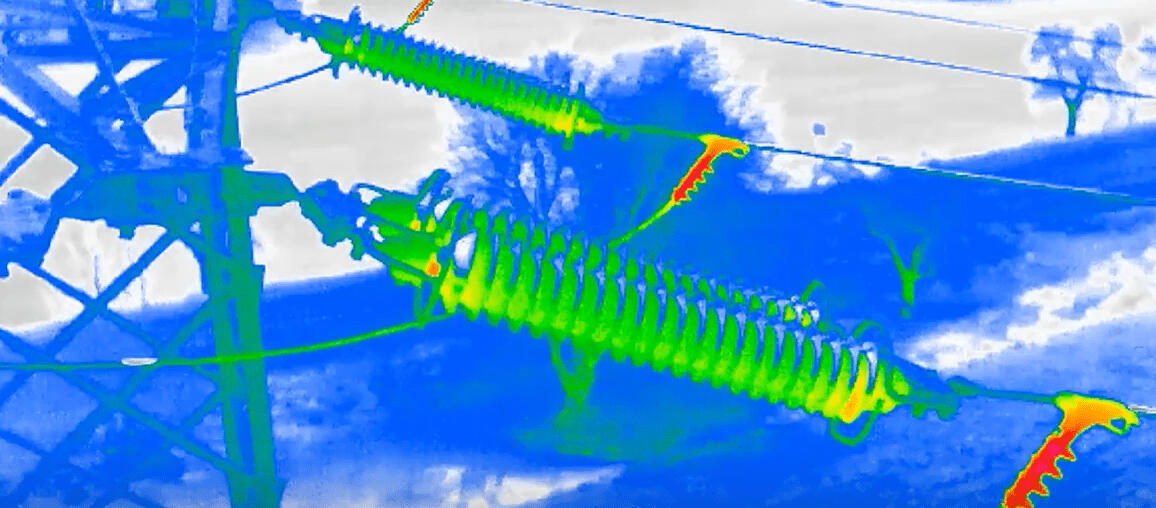
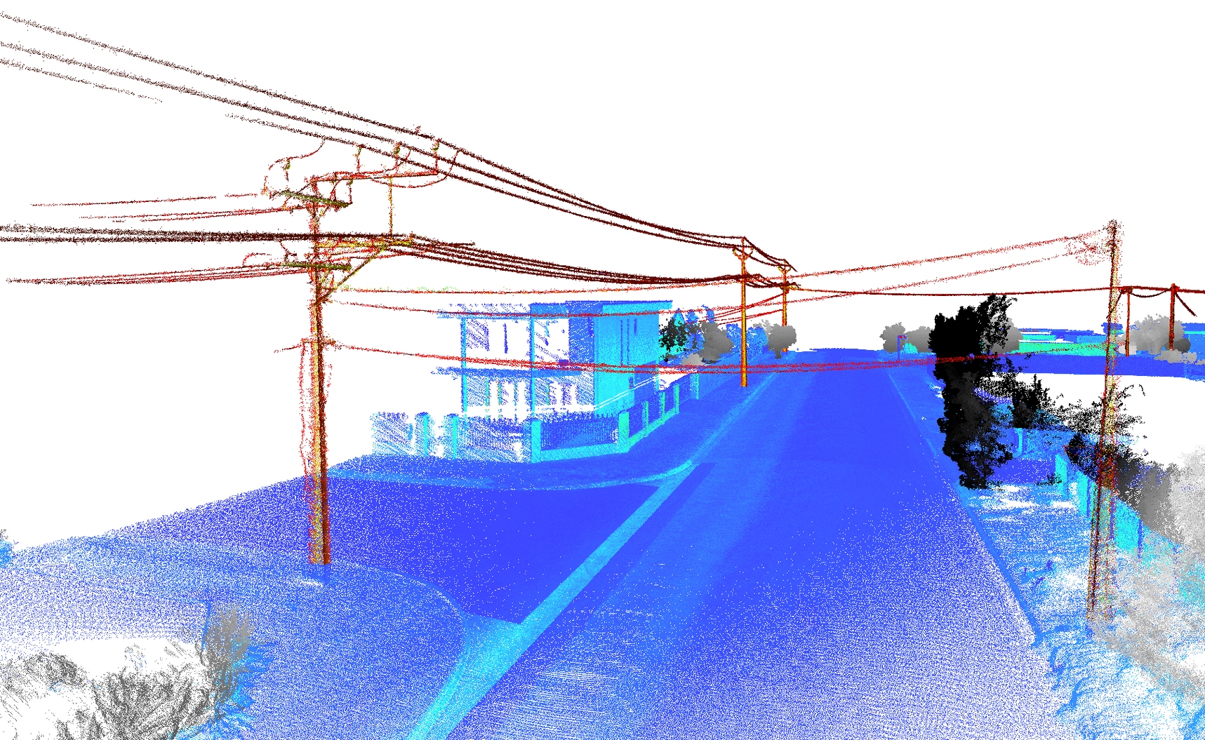
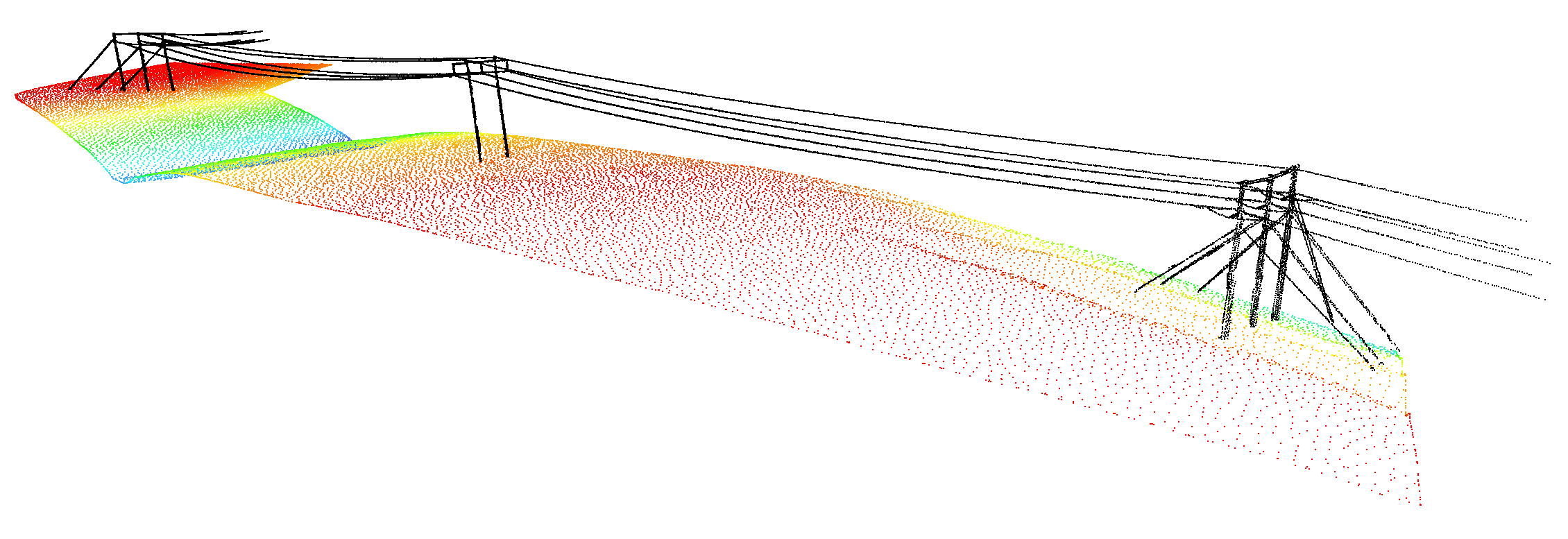
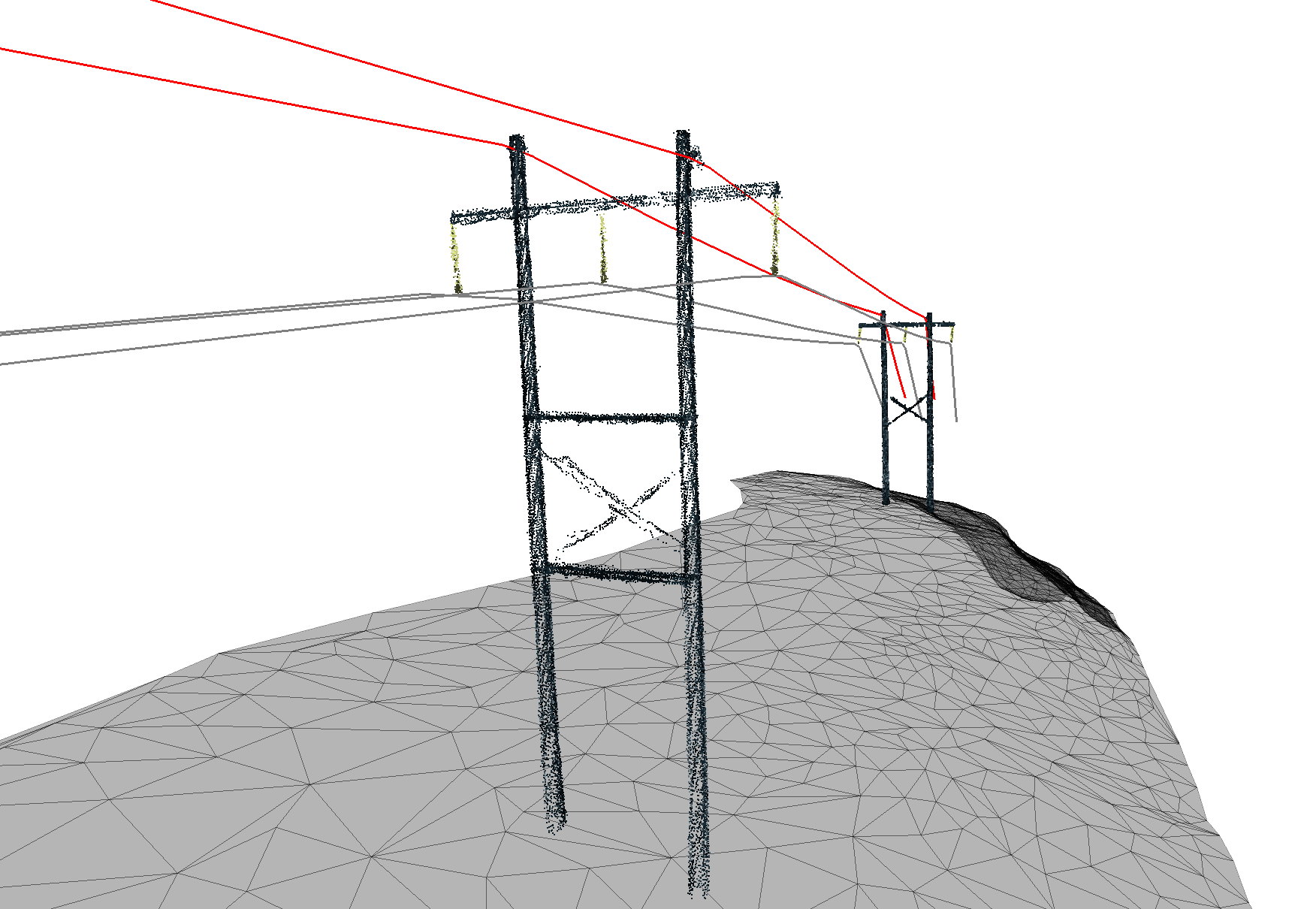
LV Powerline Survey
LV distribution networks can be mapped using vehicle- or backpack-mounted systems. High-density raw data is processed into lightweight digital twins for engineering design projects.
LiDAR Vs Vegetation Close-up
Steep, vegetated terrain can be captured in seconds, the data can then be modelled into standard survey CAD deliverables, as shown below.
Powerline OHL 3D Modelling - LiDAR to Digital Twin
RAW LiDAR data can be transformed into structured, layered, or fully classified survey models, making engineering design seamless. Below is an example of a Low Voltage (LV) Overhead Line (OHL) survey, where key elements such as poles, conductors, insulators, and ground surfaces have been extracted. Additional layers, like vegetation, are not displayed here but play a crucial role in clearance analysis.
Thanks for looking!